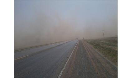
URGENT - WEATHER MESSAGE
National Weather Service Dodge City KS
317 AM CDT Tue Apr 3 2018

KSZ030-031-043>046-061>066-074>081-085>090-032000-
/O.CON.KDDC.HW.W.0008.180403T0900Z-180403T2100Z/
Trego-Ellis-Scott-Lane-Ness-Rush-Hamilton-Kearny-Finney-Hodgeman-
Pawnee-Stafford-Stanton-Grant-Haskell-Gray-Ford-Edwards-Kiowa-
Pratt-Stevens-Seward-Meade-Clark-Comanche-Barber-
Including the cities of Wakeeney, Pheifer, Hays, Scott City,
Scott State Lake, Dighton, Ness City, La Crosse, Syracuse, Lakin,
Deerfield, Garden City, Jetmore, Hanston, Larned, St. John,
Stafford, Macksville, Johnson City, Ulysses, Sublette, Satanta,
Cimarron, Montezuma, Dodge City, Kinsley, Lewis, Greensburg,
Haviland, Pratt, Hugoton, Liberal, Meade, Plains City, Fowler,
Ashland, Minneola, Coldwater, Lake Coldwater, Protection,
Medicine Lodge, and Kiowa
317 AM CDT Tue Apr 3 2018 /217 AM MDT Tue Apr 3 2018/

...HIGH WIND WARNING REMAINS IN EFFECT UNTIL 4 PM CDT /3 PM MDT/
THIS AFTERNOON...

* TIMING...Early Tuesday morning through Tuesday afternoon

* WINDS...Sustained winds 30 to 40 mph with gusts 60+ mph

* IMPACTS...Light structural damage can occur when wind gusts
  exceed 60 mph. Occasional power interruption will also be
  possible. Travel could become hazardous where there are strong
  cross winds, especially around grain elevators. Areas of
  blowing dust will also occur over open agricultural fields
  creating highly variable visibility.

PRECAUTIONARY/PREPAREDNESS ACTIONS...

A High Wind Warning means a hazardous high wind event is expected
or occurring. Sustained wind speeds of at least 40 mph or gusts
of 58 mph or more can lead to property damage.

&&

$$
URGENT - WEATHER MESSAGE
National Weather Service Pueblo CO
408 AM MDT Tue Apr 3 2018

COZ089-095-096-031800-
/O.CON.KPUB.HW.W.0008.000000T0000Z-180403T1800Z/
Crowley County-Western Kiowa County-Eastern Kiowa County-
INCLUDING Ordway, Olney Springs, Eads, and Sheridan Lake
408 AM MDT Tue Apr 3 2018

...HIGH WIND WARNING REMAINS IN EFFECT UNTIL NOON MDT TODAY...

* LOCATION...Crowley and Kiowa counties.

* CAUSE AND TIMING...A cold front has moved across the region.
  Strong northerly winds behind the front will occur until late
  morning.

* WIND...North winds 30 to 40 gusting to 60 mph.

* IMPACT...Dangerous cross winds are expected on east to west
  oriented roadways, creating a hazard for lightweight and high
  profile vehicles.

PRECAUTIONARY/PREPAREDNESS ACTIONS...

A High Wind Warning means a hazardous high wind event is expected
or occurring. Sustained wind speeds of at least 40 mph or gusts
of at least 58 mph can be expected. Property damage will be
possible. Secure your property now.

&&